Skip to content
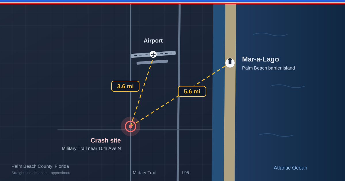
Map-style illustration of central Palm Beach County marking Mar-a-Lago on the barrier island, the airport, and the inland crash site with straight-line distances
|8 min read

Learjet Crash Near Mar-a-Lago: What We Know About the Palm Beach County Plane Crash

A Learjet 60 crashed near Greenacres in Palm Beach County on Nov. 1, 2026, killing all nine aboard about six miles from Mar-a-Lago. What we know and where Trump was.

The Short Version

On Sunday, November 1, 2026, at about 12:50 p.m. Eastern time, a Learjet 60 business jet carrying nine people crashed into a residential stretch of Palm Beach County, Florida, near Military Trail and 10th Avenue North, on the edge of Greenacres and the Cresthaven neighborhood. Transportation Secretary Sean Duffy confirmed that all nine people aboard were killed. The jet had taken off from Austin-Bergstrom International Airport in Texas and was bound for North Eleuthera Airport in the Bahamas, so it was passing over South Florida rather than arriving or departing there. Because the site lies a few miles from Mar-a-Lago, the accident was reported nationally as a plane crash near the president's estate. President Trump had left West Palm Beach aboard Air Force One roughly an hour earlier, headed to the final rallies of the midterm campaign. The National Transportation Safety Board is leading the investigation with support from the Federal Aviation Administration, and no cause has been determined. This page gathers what officials and credible news organizations had confirmed as of Monday, November 2, and marks clearly what is still unknown. It is a developing story, and we will update it as investigators release information.

Where the Crash Happened, Measured Against Mar-a-Lago and the Airport

Early reports described the distance from Mar-a-Lago in several different ways: six miles, "less than 10 miles," and nine miles. The differences come down to how the distance is measured. Using the coordinates published for the impact site, we measured a straight-line distance of about 5.6 miles (roughly 9 kilometers) west-southwest of the estate, and about 3.6 miles south-southwest of President Donald J. Trump International Airport, the field known for decades as Palm Beach International until it was renamed in July 2026. Driving distances are longer because Mar-a-Lago sits on the Palm Beach barrier island across the Lake Worth Lagoon, and reaching it from the mainland means crossing one of a handful of bridges, which likely explains the nine-mile figure. The crash site itself is inland, west of Interstate 95, where Military Trail runs past the entrance to a mobile home community. Nothing on the barrier island was affected. For a fuller picture of how the estate sits between the ocean and the lagoon, our guide to where Mar-a-Lago is and why it dominates presidential records maps the geography, and the Mar-a-Lago location page shows the property's confirmed visit history.

Where Trump Was When the Jet Went Down

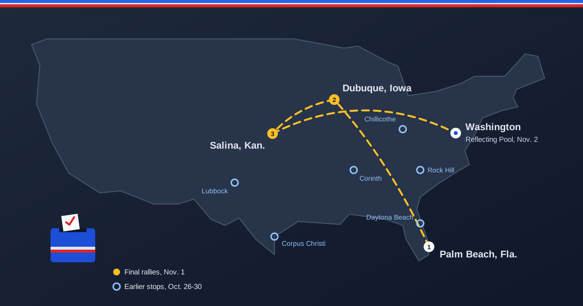
The president spent the final weekend before the November 3 midterm elections at Mar-a-Lago and left on Sunday for back-to-back in-person rallies in Dubuque, Iowa, and Salina, Kansas. AFP reported that he boarded Air Force One at President Donald J. Trump International Airport at 11:55 a.m., and White House pool reports placed the departure around noon, so he was already on his way when the Learjet came down at about 12:50 p.m. He landed in Dubuque that afternoon and flew from Salina to Joint Base Andrews that night. No official has suggested any link between the crash and the president's travel, and the jet's route from Texas to the Bahamas had no connection to Palm Beach's airport. As of Monday afternoon we had not found a public statement on the crash from the president or the White House; Transportation Secretary Duffy has spoken for the administration. In our location record, the day reads as a straightforward travel day: Mar-a-Lago in the morning, a Midwest rally swing in the afternoon and evening. That distinction matters for anyone using a tracker like ours. A dramatic event near a presidential property generates a burst of "where is Trump" searches, but proximity is not presence. Our location history timeline records where the president was confirmed to be by multiple independent reports, and a nearby emergency does not change that record unless the president was actually there.

What the Crew Reported in the Final Minutes

Air traffic control audio and flight-tracking data, as reported by the Associated Press, CNN, ABC News and others, outline the last minutes of the flight. The Learjet was eastbound over Florida at about 35,000 feet when the crew reported turbulence, icing, precipitation and an outside air temperature of around minus 47 degrees Celsius, and asked to climb to 37,000 feet. Shortly afterward a pilot declared a mayday. ABC News, citing the FAA, reported that the jet fell from 35,250 feet to 8,750 feet in about one minute, and Flightradar24 data showed descent rates above 30,000 feet per minute. The BBC reported that the final transmission came roughly 35 seconds after the mayday call. Dashcam video from a passing car shows the aircraft striking the ground nearly vertically. The weather was poor across South Florida that afternoon, with thunderstorms, heavy rain and lightning reported in the area and a National Weather Service flood watch in effect for Palm Beach County. Every detail in this section is reported information drawn from audio and tracking data, not an investigative finding. The NTSB will establish the actual sequence of events, and early accounts of a fast-moving accident are sometimes revised.

What Investigators Have Said So Far

The NTSB is leading the investigation, with the FAA and Bombardier, the manufacturer of the Learjet line, assisting. NTSB board member Tom Chapman told reporters "the weather conditions are a major focus of the investigation" and that there is "some evidence that there was some breakup of the aircraft before impact." He asked the public not to move any debris, because scattered wreckage helps investigators reconstruct what happened in the air. The agency hopes to recover the cockpit voice recorder, although Chapman said it was not yet clear whether the jet was carrying one. Senior investigator Timothy Monville told reporters, "We have a lot of work to do on scene," and said recovery work would take several days. FAA records list the aircraft, a 2004 Learjet 60 registered N722BD, as owned by a Delaware company. Bombardier said it could not comment on a potential cause until the investigation is complete. For readers wondering about timing: the NTSB usually publishes a preliminary report within several weeks of an accident, while the final report with a probable cause generally takes a year or longer.

On the Ground: Evacuations, Closures, and Injuries

The impact left a large crater beside the road at the entrance to a mobile home park and scattered debris across nearby homes and businesses. Palm Beach County Commissioner Joel Flores said about 600 residents were helped by the Red Cross and moved to two county shelters, and he described the site as a crime scene while investigators work. The crash severed power lines and underground water mains, and Military Trail was closed between Cresthaven Boulevard and 10th Avenue North; officials warned that the road could stay closed for a month or more. John I. Leonard Community High School, near the site, closed on Monday. Governor Ron DeSantis called the crash "cataclysmic" and initially said there were no known injuries on the ground; the NTSB later said one man leaving the area was injured. Anyone who lives or commutes in the area should follow Palm Beach County Fire Rescue and the Sheriff's Office for closure updates, avoid the cordoned area, and leave any debris where it lies.

The People Aboard

As of Monday, officials had not released the names of the nine people killed. The New York Times reported that the mother of one crew member identified her daughter as Nathalia Filgueiras, a 20-year-old pilot from Boca Raton who earned her pilot's license at 17, had logged more than 1,300 flight hours, and worked for a Fort Lauderdale charter company. It was not yet clear who was at the controls. NASA Administrator Jared Isaacman, himself an experienced pilot, said "she was doing her job, communicating with ATC right to the end in a terrifying situation," and urged people not to criticize the crew before investigators have done their work. Aviation experts quoted in early coverage noted that icing can form at almost any altitude and that anti-ice and weather radar systems can fail, and they cautioned against assigning blame before the evidence is in. We will add confirmed details about the other passengers only when officials or families make them public.

Fact-Checking the Rumors

Because the crash happened a few miles from Mar-a-Lago and within the same hour that the president left town, speculation spread quickly on social media, including posts claiming the jet was shot down or had strayed into protected airspace. Nothing in any official statement supports those claims. The NTSB, FAA and Department of Transportation are treating this as an accident investigation, and their early focus is on weather, icing and the possibility that the aircraft broke up in flight. No agency has reported an airspace violation or an interception involving this jet. A bit of context explains why the airspace theory does not fit the known facts. The temporary flight restrictions that the FAA sets around the president in Palm Beach normally run from the surface up to, but not including, 18,000 feet, and airliners and business jets routinely pass above them at cruising altitude. The Learjet's trouble began near 35,000 feet on a route crossing the state toward the Bahamas, and the president had already departed. Our explainer on presidential security zones and restricted airspace covers how those restrictions work. When a claim like this circulates, the safest habit is the one in our reproducible fact-check method: trace it to an on-the-record source before sharing it.

Frequently Asked Questions

Was Trump at Mar-a-Lago when the plane crashed? No. He had spent the weekend at Mar-a-Lago but left West Palm Beach aboard Air Force One around noon on November 1, roughly an hour before the crash, for rallies in Iowa and Kansas. How far was the crash from Mar-a-Lago? About 5.6 miles in a straight line, west-southwest of the estate, by our measurement. Driving distance is longer because Mar-a-Lago is on the Palm Beach barrier island. What kind of plane crashed, and where was it going? A 2004 Learjet 60 business jet, registration N722BD, flying from Austin, Texas, to North Eleuthera in the Bahamas, with nine people aboard. What caused the Learjet crash? No cause has been determined. The NTSB says weather is a major focus and that some evidence suggests the aircraft began breaking up before impact. Was the jet shot down? There is no evidence of that. No official has suggested any military or security involvement, and no agency has reported an airspace violation. Which roads are closed? Military Trail between Cresthaven Boulevard and 10th Avenue North was closed, and officials warned the closure could last a month or more.

Sources

Learjet crash Floridaplane crash near Mar-a-LagoPalm Beach County plane crashGreenacres plane crashLearjet 60 crashWest Palm Beach plane crashCresthaven plane crashMilitary Trail plane crashFlorida plane crash nine killedwas Trump at Mar-a-Lago during the plane crash
LT

LocateTrump Research Team

An independent team of developers, data analysts, and researchers tracking presidential location and activity using publicly available information from 10+ major news sources. Operating continuously since January 20, 2025. All content follows our editorial standards for source verification and accuracy.

Related Articles

Further Reading

Need deeper document-level context? Continue with carefully sourced long-form coverage.

Research Pathways for This Topic

Use these targeted internal paths to move from this article into related hubs, timelines, and data-backed tracking pages.

Explore LocateTrump

See presidential location data in action with our live tools.